ADATEPE Village Digital Map | Boundaries of Villages
Çanakkale ilinde,
Lapseki ilçesinde, köyler içinde,
Nüfus yoğunluğu en fazla listesinde 1. Adatepe 1. sırada yer alan, öne çıkan mahalledir.
Ekonomik refahın merkezi listesinde 2. Adatepe sıralamada ikinci sırada yer alır.
Konutlu aile sayısında lider listesinde 1. Adatepe en üst sırada bulunan yerleşimlerden biridir.
Konut hacmi en yüksek listesinde 1. Adatepe 1. sırada yer alan, öne çıkan mahalledir.
İşletme sayısı en kalabalık listesinde 5. Adatepe beşinci sırada bulunmasıyla üst sıralarda yer alır.
Doğurganlık etkisi yüksek listesinde 1. Adatepe istatistiksel olarak ilk sıradadır.
| Adi | ADATEPE Province Affiliated | ÇANAKKALE District Affiliated | LAPSEKI Postal code | 17802 Number of Streets | 2 Population Density km2-people | 66.51 Number of Apartments with business Licenses | 43 Number of Apartments with Residential Licenses | 867 Number of Households / Families | 387 Total Population | 1102 Male Population | 555 Woman Population | 547 Income Per Person - Spendable TL-Month | 8.421 |
|---|
ADATEPE Village Map | Geography and Natural Features
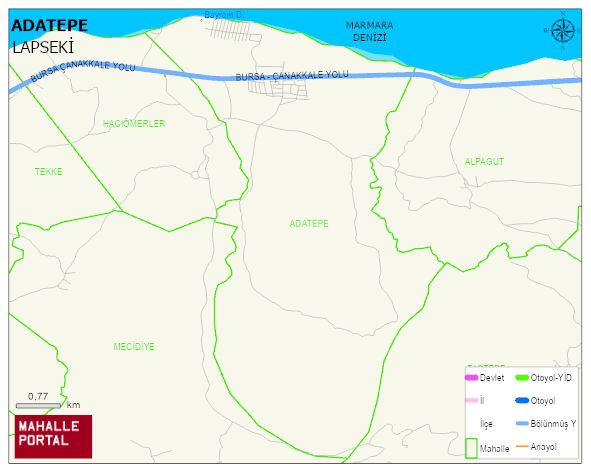
ADATEPE Village Digital Map | Boundaries of Villages
ADATEPE Village – Population, Postal Code, Number of Workplaces
ADATEPE village LAPSEKI district of ÇANAKKALE province. UAVT (National Address Database Code) Village Code: 8488. Postal Code: 17802. ADATEPE 2 streets and avenues, 43 independent business licensed apartments, 820 residential licensed apartments, 396 households. 1135 people live in this settlement. 569 male, 566 female. 149 people have never married, 687 people are married, 21 people are divorced and 113 people have passed away. The number of people aged 60 and over is 348. The population rate of 60+ people is % 30 and the ratio of children under the age of 10 to the population is % 9 LAPSEKI -in the district- 6. the most crowded neighbourhood.
Leave a Comment