ALPAGUT Village Digital Map | Mountains, Rivers and Elevation Details
Bolu ilinde,
Mudurnu ilçesinde, köyler içinde,
Nüfusu en fazla listesinde 4. Alpağut istatistiksel olarak 4. sıradadır.
Gelir düzeyi bakımından şampiyo listesinde 2. Alpağut sıralamada ikinci sırada yer alır.
Mesken sayısı bakımından öne çıkan listesinde 4. Alpağut sıralamada dördüncü sıradadır.
Ticarî yoğunluk açısından önde listesinde 3. Alpağut sıralamada üçüncü sırada yer alır.
Arsa yatırımının en kazançlı olduğu listesinde 1. Alpağut istatistiklere göre en üst sıradadır.
Aile içi genç oranı fazla listesinde 4. Alpağut sıralamada dördüncü sıradadır.
Sokak ağı güçlü olan listesinde 5. Alpağut sıralamada beşinci sırada yer almaktadır.
| Adi | ALPAGUT Province Affiliated | BOLU District Affiliated | MUDURNU Postal code | 14802 Number of Streets | 7 Population Density km2-people | 22.09 Number of Apartments with business Licenses | 76 Number of Apartments with Residential Licenses | 220 Number of Households / Families | 98 Total Population | 315 Male Population | 160 Woman Population | 155 Income Per Person - Spendable TL-Month | 8.853 |
|---|
ALPAGUT Village Map | Interactive Neighbourhoods
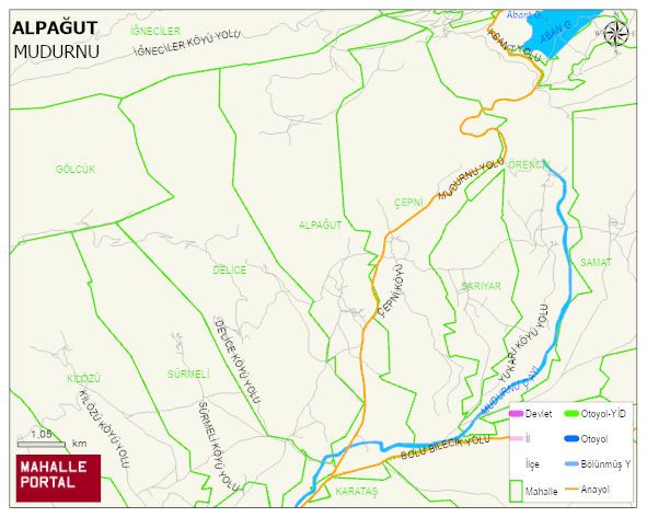
ALPAGUT Village Digital Map | Mountains, Rivers and Elevation Details
ALPAGUT Village – Population, Postal Code, Number of Workplaces
ALPAGUT village MUDURNU district of BOLU province. UAVT (National Address Database Code) Village Code: 6959. Postal Code: 14802. ALPAGUT 7 streets and avenues, 75 independent business licensed apartments, 220 residential licensed apartments, 99 households. 319 people live in this settlement. 163 male, 156 female. 60 and over is 87. The population rate of 60+ people is % 27 and the ratio of children under the age of 10 to the population is % 7
Leave a Comment