TOP 10: NÜFUS
Muğla ilinde,
Marmaris ilçesinde, mahalleler içinde,
Nüfus sıralamasında 1. Armutalan bölge sıralamasında birinci sıradadır.
Aile büyüklüğü sıralamasında 1. Armutalan istatistiksel olarak yer alır.
Mesken sayısı sıralamasında 1. Armutalan 1. sırada, bölgenin en önde gelen yerleşimidir.
Ticari yoğunluk sıralamasında 5. Armutalan beşinci konumda bulunan mahalledir.
Sokak ağına ilişkin sıralamada 1. Armutalan sıralamada en üstte yer almaktadır.
| Adi | ARMUTALAN Province Affiliated | MUGLA District Affiliated | MARMARIS Postal code | 48700 Number of Streets | 195 Population Density km2-people | 4830.59 Number of Apartments with business Licenses | 1400 Number of Apartments with Residential Licenses | 5041 Number of Households / Families | 3913 Total Population | 11450 Male Population | 5813 Woman Population | 5637 Income Per Person - Spendable TL-Month | 36.072 |
|---|
ARMUTALAN Neighbourhood Map | Geography and Natural Features
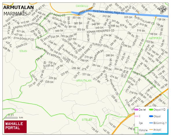
ARMUTALAN Neighbourhood Digital Map | Detailed Villages and Neighbourhoods
ARMUTALAN Neighbourhood – Population, Postal Code, Number of Workplaces
ARMUTALAN neighborhood is located in MARMARIS district of MUGLA province. UAVT (National Address Database Code) Neighborhood Code: 176429. Postal Code: 48700. The population density is -per square kilometer- 4798 people. ARMUTALAN 195 streets and avenues, 1486 independent business licensed apartments, 4997 residential licensed apartments, 3907 households. 11382 people live in this settlement. 5780 male, 5602 female. 2393 people have never married, 5493 people are married, 1008 people are divorced and 362 people have passed away. The number of people aged 60 and over is 1786. The population rate of 60+ people is % 15 and the ratio of children under the age of 10 to the population is % 12 MARMARIS -in the district- 1. the most crowded neighbourhood.