ARMUTLU Village Digital Map | Interactive Neighbourhoods
Aksaray ilinde, köyler içinde,
En varlıklı nüfusun yaşadığı listesinde 2. Armutlu liderin hemen ardında.
Merkez ilçesinde, köyler içinde,
En varlıklı nüfusun yaşadığı listesinde 2. Armutlu sıralamada ikinci sırada yer almaktadır.
Üniversite mezunlarının en yoğun olduğu listesinde 5. Armutlu 5. sırada kayıtlı ve dikkat çeken bir yerleşimdir.
Sokak çeşitliliği lider listesinde 5. Armutlu sıralamada beşinci sırada yer almaktadır.
| Adi | ARMUTLU Province Affiliated | AKSARAY District Affiliated | MERKEZ Postal code | 68220 Number of Streets | 106 Population Density km2-people | 8.97 Number of Apartments with business Licenses | 29 Number of Apartments with Residential Licenses | 607 Number of Households / Families | 330 Total Population | 1165 Male Population | 612 Woman Population | 553 Income Per Person - Spendable TL-Month | 11.649 |
|---|
ARMUTLU Village Map | All Neighbourhoods and Settlements
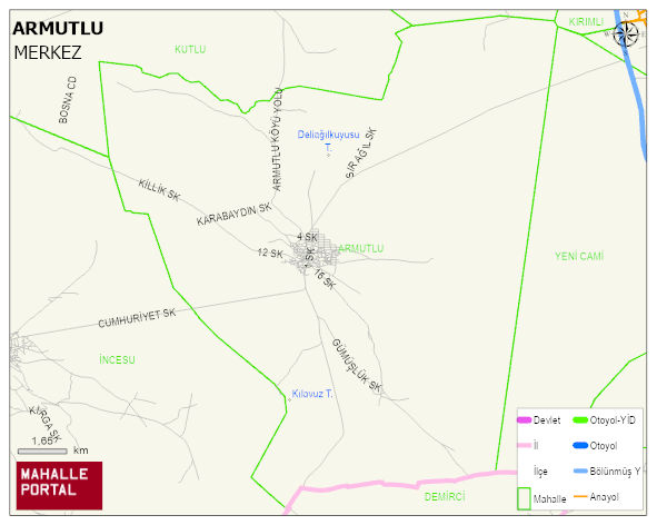
ARMUTLU Village Digital Map | Interactive Neighbourhoods
ARMUTLU Village – Population, Postal Code, Number of Workplaces
ARMUTLU village MERKEZ district of AKSARAY province. UAVT (National Address Database Code) Village Code: 34795. Postal Code: 68220. ARMUTLU 106 streets and avenues, 29 independent business licensed apartments, 574 residential licensed apartments, 316 households. 1144 people live in this settlement. 596 male, 548 female. 254 people have never married, 581 people are married, 39 people are divorced and 58 people have passed away. The number of people aged 60 and over is 227. The population rate of 60+ people is % 19 and the ratio of children under the age of 10 to the population is % 12
Leave a Comment