ARMUTLU Village Digital Map | Interactive Neighbourhoods
Amasya ilinde,
Suluova ilçesinde, köyler içinde,
Nüfusu en fazla listesinde 3. Armutlu sıralamada üçüncü sırada yer almaktadır.
Gelir düzeyi bakımından şampiyo listesinde 2. Armutlu ikinci konumda bulunan mahalledir.
En geniş aile yerleşimi listesinde 2. Armutlu sıralamada ikinci sırada yer almaktadır.
Mesken sayısı bakımından öne çıkan listesinde 2. Armutlu sıralamada ikinci sırada yer almaktadır.
Banka ATM’lerinde lider konumda listesinde 5. Armutlu sıralamada beşinci sırada yer almaktadır.
Aile içi genç oranı fazla listesinde 4. Armutlu dördüncü sırada bulunmasıyla dikkat çeker.
| Adi | ARMUTLU Province Affiliated | AMASYA District Affiliated | SULUOVA Postal code | 05502 Number of Streets | 2 Population Density km2-people | 75.76 Number of Apartments with business Licenses | 5 Number of Apartments with Residential Licenses | 393 Number of Households / Families | 155 Total Population | 447 Male Population | 250 Woman Population | 197 Income Per Person - Spendable TL-Month | 8.996 |
|---|
ARMUTLU Village Map | Terrain and Topography
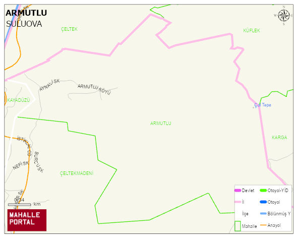
ARMUTLU Village Digital Map | Interactive Neighbourhoods
ARMUTLU Village – Population, Postal Code, Number of Workplaces
ARMUTLU village SULUOVA district of AMASYA province. UAVT (National Address Database Code) Village Code: 2369. Postal Code: 5502. ARMUTLU 2 streets and avenues, 4 independent business licensed apartments, 393 residential licensed apartments, 157 households. 458 people live in this settlement. 250 male, 208 female. 86 people have never married, 225 people are married, 48 people are divorced and 30 people have passed away. The number of people aged 60 and over is 104. The population rate of 60+ people is % 22 and the ratio of children under the age of 10 to the population is % 8
Leave a Comment