TOP 10: NÜFUS
İstanbul ilinde,
Küçükçekmece ilçesinde, mahalleler içinde,
İşyeri sayısında zirvede listesinde 3. Atatürk sıralamada üçüncü sırada yer almaktadır.
Eğitim seviyesi en düşük listesinde 5. Atatürk istatistiksel olarak yer alır.
En fazla ATM bulunan listesinde 5. Atatürk listede 5. sırada yer alır.
Çocuk nüfusu en yüksek listesinde 4. Atatürk kayıtlarda dördüncü basamakta gözükmektedir.
Sokak sayısı en yüksek listesinde 4. Atatürk istatistik listelerinde 4. sıradadır.
| Adi | ATATÜRK Province Affiliated | ISTANBUL District Affiliated | KÜÇÜKÇEKMECE Postal code | 34307 Number of Streets | 128 Population Density km2-people | 39100.90 Number of Apartments with business Licenses | 3251 Number of Apartments with Residential Licenses | 16888 Number of Households / Families | 11873 Total Population | 41529 Male Population | 21274 Woman Population | 20255 Income Per Person - Spendable TL-Month | 24.164 |
|---|
ATATÜRK Neighbourhood Map | Terrain and Topography
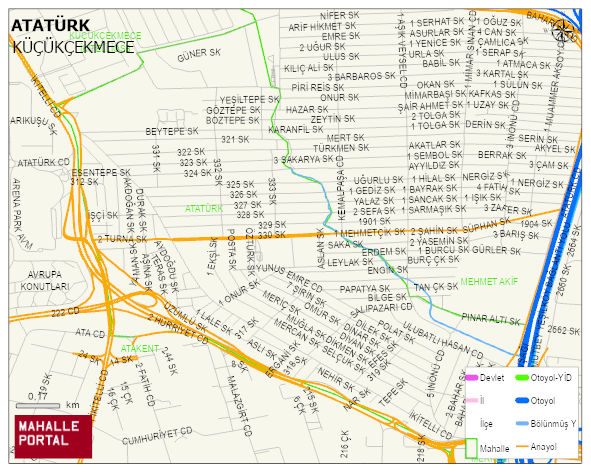
ATATÜRK Neighbourhood Digital Map | Updated Neighbourhood Map
ATATÜRK Neighbourhood – Population, Postal Code, Number of Workplaces
ATATÜRK neighborhood is located in KÜÇÜKÇEKMECE district of ISTANBUL province. UAVT (National Address Database Code) Neighborhood Code: 40591. Postal Code: 34307. The population density is -per square kilometer- 39938 people. ATATÜRK 128 streets and avenues, 3182 independent business licensed apartments, 16833 residential licensed apartments, 12012 households. 42447 people live in this settlement. 21854 male, 20593 female. 11074 people have never married, 19315 people are married, 1424 people are divorced and 1009 people have passed away. The number of people aged 60 and over is 3085. The population rate of 60+ people is % 7 and the ratio of children under the age of 10 to the population is % 14 KÜÇÜKÇEKMECE -in the district- 8. the most crowded neighbourhood.