ATMALI Village Digital Map | Mountains, Rivers and Elevation Details
Adıyaman ilinde, köyler içinde,
Ev–hane sayısı en çok olan listesinde 4. Atmalı tepedeki dört isimden biri.
Besni ilçesinde, köyler içinde,
En yoğun nüfuslu listesinde 1. Atmalı istatistiklere göre 1. sırada yer almaktadır.
Ekonomik gücü en yüksek listesinde 4. Atmalı sıralamada dördüncü sıradadır.
Ev–hane sayısı en çok olan listesinde 1. Atmalı istatistiklere göre en üst sıradadır.
Ev sayısı bakımından ilk sırada listesinde 1. Atmalı bölge içi sıralamada birinci konumdadır.
Aile yapısının en genç olduğu listesinde 3. Atmalı şehir içi sıralamada 3. sıradadır.
| Adi | ATMALI Province Affiliated | ADIYAMAN District Affiliated | BESNI Postal code | 02340 Number of Streets | 3 Population Density km2-people | 56.31 Number of Apartments with business Licenses | 41 Number of Apartments with Residential Licenses | 467 Number of Households / Families | 386 Total Population | 1636 Male Population | 836 Woman Population | 800 Income Per Person - Spendable TL-Month | 7.160 |
|---|
ATMALI Village Map | Satellite View and Local Boundaries
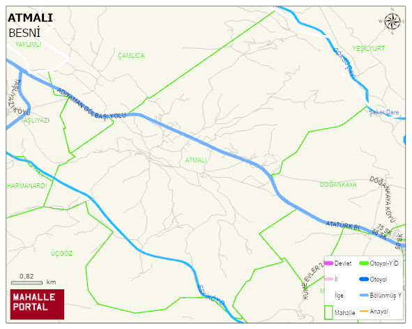
ATMALI Village Digital Map | Mountains, Rivers and Elevation Details
ATMALI Village – Population, Postal Code, Number of Workplaces
ATMALI village BESNI district of ADIYAMAN province. UAVT (National Address Database Code) Village Code: 714. Postal Code: 2340. ATMALI 3 streets and avenues, 41 independent business licensed apartments, 462 residential licensed apartments, 383 households. 1644 people live in this settlement. 843 male, 801 female. 327 people have never married, 743 people are married, 25 people are divorced and 66 people have passed away. The number of people aged 60 and over is 226. The population rate of 60+ people is % 13 and the ratio of children under the age of 10 to the population is % 18 BESNI -in the district- 9. the most crowded neighbourhood.
Leave a Comment