TOP 10: NÜFUS
İstanbul ilinde,
Ümraniye ilçesinde, mahalleler içinde,
Nüfus yoğunluğu en fazla listesinde 3. Çakmak üçüncü konumda bulunan mahalledir.
Konutlu aile sayısında lider listesinde 3. Çakmak sıralamada üçüncü sırada yer almaktadır.
Konut hacmi en yüksek listesinde 3. Çakmak kayıtlarda 3. sırada yer almıştır.
| Adi | ÇAKMAK Province Affiliated | ISTANBUL District Affiliated | ÜMRANIYE Postal code | 34774 Number of Streets | 67 Population Density km2-people | 44395.36 Number of Apartments with business Licenses | 1025 Number of Apartments with Residential Licenses | 14595 Number of Households / Families | 12374 Total Population | 38141 Male Population | 19099 Woman Population | 19042 Income Per Person - Spendable TL-Month | 20.486 |
|---|
ÇAKMAK Neighbourhood Map | Mountains, Rivers and Elevation Details
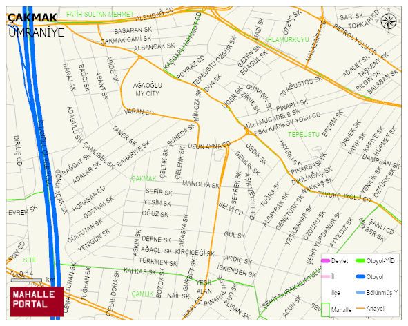
ÇAKMAK Neighbourhood Digital Map | Mountains, Rivers and Elevation Details
ÇAKMAK Neighbourhood – Population, Postal Code, Number of Workplaces
ÇAKMAK neighborhood is located in ÜMRANIYE district of ISTANBUL province. UAVT (National Address Database Code) Neighborhood Code: 40738. Postal Code: 34774. The population density is -per square kilometer- 44195 people. ÇAKMAK 67 streets and avenues, 1024 independent business licensed apartments, 14536 residential licensed apartments, 12294 households. 37993 people live in this settlement. 19043 male, 18950 female. 9150 people have never married, 18413 people are married, 1714 people are divorced and 1073 people have passed away. The number of people aged 60 and over is 3540. The population rate of 60+ people is % 9 and the ratio of children under the age of 10 to the population is % 13 ÜMRANIYE -in the district- 3. the most crowded neighbourhood.