TOP 10: NÜFUS
Erzurum ilinde,
İspir ilçesinde, mahalleler içinde,
Nüfus sıralamasında 3. Çamlıkaya sıralamada üçüncü sırada yer almaktadır.
Aile büyüklüğü sıralamasında 3. Çamlıkaya kayıtlarda üçüncü sırada gözükür.
Mesken sayısı sıralamasında 3. Çamlıkaya sıralamada üçüncü sırada yer almaktadır.
Aile içindeki genç oranı sıralamasında 4. Çamlıkaya dördüncü konumda bulunan mahalledir.
Üst yaş grubunda lider listesinde 5. Çamlıkaya sıralamada beşinci sırada yer almaktadır.
Sokak ağına ilişkin sıralamada 2. Çamlıkaya ikinci sırada yer almaktadır.
| Adi | ÇAMLIKAYA Province Affiliated | ERZURUM District Affiliated | ISPIR Postal code | 25900 Number of Streets | 37 Population Density km2-people | 4.38 Number of Apartments with business Licenses | 37 Number of Apartments with Residential Licenses | 1094 Number of Households / Families | 251 Total Population | 597 Male Population | 292 Woman Population | 305 Income Per Person - Spendable TL-Month | 4.808 |
|---|
ÇAMLIKAYA Neighbourhood Map | Mountains, Rivers and Elevation Details
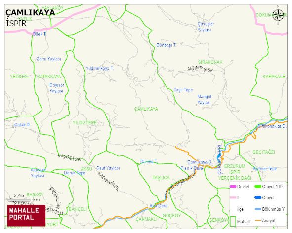
ÇAMLIKAYA Neighbourhood Digital Map | Updated Neighbourhood Map
ÇAMLIKAYA Neighbourhood – Population, Postal Code, Number of Workplaces
ÇAMLIKAYA neighborhood is located in ISPIR district of ERZURUM province. UAVT (National Address Database Code) Neighborhood Code: 189039. Postal Code: 25900. The population density is -per square kilometer- 4 people. ÇAMLIKAYA 37 streets and avenues, 38 independent business licensed apartments, 1093 residential licensed apartments, 265 households. 672 people live in this settlement. 332 male, 340 female. 60 and over is 241. The population rate of 60+ people is % 35 and the ratio of children under the age of 10 to the population is % 7 ISPIR -in the district- 3. the most crowded neighbourhood.