TOP 10: NÜFUS
Adıyaman ilinde,
Kahta ilçesinde, mahalleler içinde,
Okuma-yazma oranı düşük bölgeler listesinde 3. Cumhuriyet sıralamada üçüncü sırada yer almaktadır.
Single yaşam oranı yüksek listesinde 2. Cumhuriyet istatistiklerde ikinci olarak listelenir.
Yaşça büyük nüfus oranı yüksek listesinde 5. Cumhuriyet 5. sırada konumlanan önemli mahallelerden biridir.
| Adi | CUMHURIYET Province Affiliated | ADIYAMAN District Affiliated | KAHTA Postal code | 02440 Number of Streets | 12 Population Density km2-people | 232.99 Number of Apartments with business Licenses | 11 Number of Apartments with Residential Licenses | 232 Number of Households / Families | 194 Total Population | 797 Male Population | 396 Woman Population | 401 Income Per Person - Spendable TL-Month | 7.134 |
|---|
BÖLÜKYAYLA BELDESI CUMHURIYET Neighbourhood Map | Detailed Villages and Neighbourhoods
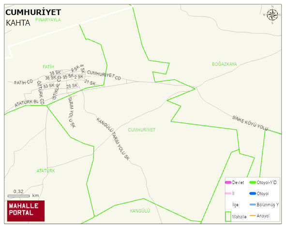
CUMHURIYET Neighbourhood Digital Map | Detailed Villages and Neighbourhoods
CUMHURIYET Neighbourhood – Population, Postal Code, Number of Workplaces
CUMHURIYET - BÖLÜKYAYLA neighborhood is located in BÖLÜKYAYLA beldesi KAHTA district of ADIYAMAN province. UAVT (National Address Database Code) Neighborhood Code: 565. Postal Code: 2440. The population density is -per square kilometer- 242 people. CUMHURIYET - BÖLÜKYAYLA 12 streets and avenues, 10 independent business licensed apartments, 228 residential licensed apartments, 196 households. 828 people live in this settlement. 407 male, 421 female. 60 and over is 119. The population rate of 60+ people is % 14 and the ratio of children under the age of 10 to the population is % 14