TOP 10: NÜFUS
Osmaniye ilinde,
Düziçi ilçesinde, mahalleler içinde,
Konut sayısının zirvede olduğu listesinde 5. Cumhuriyet beşinci konumda bulunan mahalledir.
İşyeri sayısında zirvede listesinde 2. Cumhuriyet ikinci sırada yer almaktadır.
En fazla ATM bulunan listesinde 4. Cumhuriyet istatistiklere göre dördüncü basamakta yer alır.
| Adi | CUMHURIYET Province Affiliated | OSMANIYE District Affiliated | DÜZIÇI Postal code | 80600 Number of Streets | 65 Population Density km2-people | 4898.53 Number of Apartments with business Licenses | 542 Number of Apartments with Residential Licenses | 1681 Number of Households / Families | 1082 Total Population | 3476 Male Population | 1735 Woman Population | 1741 Income Per Person - Spendable TL-Month | 11.946 |
|---|
CUMHURIYET Neighbourhood Map | Satellite View and Local Boundaries
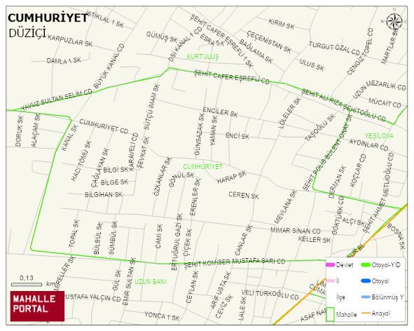
CUMHURIYET Neighbourhood Digital Map | Updated Neighbourhood Map
CUMHURIYET Neighbourhood – Population, Postal Code, Number of Workplaces
CUMHURIYET neighborhood is located in DÜZIÇI district of OSMANIYE province. UAVT (National Address Database Code) Neighborhood Code: 91081. Postal Code: 80600. The population density is -per square kilometer- 4844 people. CUMHURIYET 64 streets and avenues, 542 independent business licensed apartments, 1674 residential licensed apartments, 1079 households. 3439 people live in this settlement. 1709 male, 1730 female. 597 people have never married, 1815 people are married, 66 people are divorced and 143 people have passed away. The number of people aged 60 and over is 559. The population rate of 60+ people is % 16 and the ratio of children under the age of 10 to the population is % 15 DÜZIÇI -in the district- 6. the most crowded neighbourhood.