DERELI Village Digital Map | Boundaries of Villages
Osmaniye ilinde, köyler içinde, En çok kişinin yaşadığı4. Dereli üst performans grubunda bulunuyor.
En yüksek gelir seviyesine sahip listesinde 3. Dereli üst sıralarda yer aldı.
En fazla hanenin yaşadığı listesinde 4. Dereli zirve hattına yakın konumda.
Merkez ilçesinde, köyler içinde, En çok kişinin yaşadığı3. Dereli 3. sırada kayıtlı ve öne çıkan bir alandır.
En yüksek gelir seviyesine sahip listesinde 3. Dereli sıralamada üçüncü sırada yer almaktadır.
En fazla hanenin yaşadığı listesinde 3. Dereli üçüncü konumda bulunan mahalledir.
Çocuk nüfusu en yüksek listesinde 5. Dereli beşinci konumda bulunan mahalledir.
| Adi | DERELI Province Affiliated | OSMANIYE District Affiliated | MERKEZ Postal code | 80080 Number of Streets | 3 Population Density km2-people | 227.51 Number of Apartments with business Licenses | 35 Number of Apartments with Residential Licenses | 703 Number of Households / Families | 503 Total Population | 1794 Male Population | 917 Woman Population | 877 Income Per Person - Spendable TL-Month | 10.271 |
|---|
DERELI Village Map | Satellite View and Local Boundaries
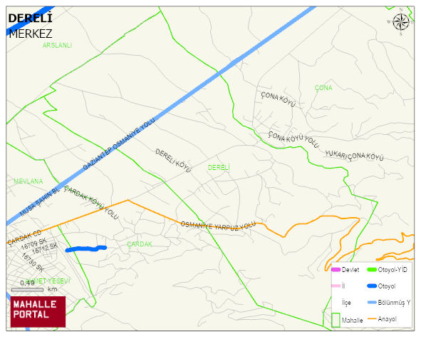
DERELI Village Digital Map | Boundaries of Villages
DERELI Village – Population, Postal Code, Number of Workplaces
DERELI village MERKEZ district of OSMANIYE province. UAVT (National Address Database Code) Village Code: 37161. Postal Code: 80080. DERELI 3 streets and avenues, 35 independent business licensed apartments, 688 residential licensed apartments, 501 households. 1783 people live in this settlement. 905 male, 878 female. 390 people have never married, 845 people are married, 36 people are divorced and 77 people have passed away. The number of people aged 60 and over is 254. The population rate of 60+ people is % 14 and the ratio of children under the age of 10 to the population is % 15
Leave a Comment