TOP 10: NÜFUS
Ankara ilinde, mahalleler içinde,
Gelir düzeyi sıralamasında 4. Devlet rekabetin içinde kalmayı başardı.
Bekârlık oranı sıralamasında 1. Devlet performansın zirvesinde.
Çankaya ilçesinde, mahalleler içinde,
Gelir düzeyi sıralamasında 4. Devlet istatistik listelerinde 4. sıradadır.
Servet sahibi kişi yoğunluğu sıralamasında 5. Devlet istatistiksel sıralamada beşinci konumdadır.
Banka ATM'lerine ilişkin sıralamada 5. Devlet 5. sırada kayıtlı ve dikkat çeken bir yerleşimdir.
Bekârlık oranı sıralamasında 1. Devlet 1. sırada yer alan, öne çıkan mahalledir.
| Adi | DEVLET Province Affiliated | ANKARA District Affiliated | ÇANKAYA Postal code | 06420 Number of Streets | 13 Population Density km2-people | 1391.81 Number of Apartments with business Licenses | 67 Number of Apartments with Residential Licenses | 697 Number of Households / Families | 466 Total Population | 7144 Male Population | 6421 Woman Population | 723 Income Per Person - Spendable TL-Month | 61.169 |
|---|
DEVLET Neighbourhood Map | Terrain and Topography
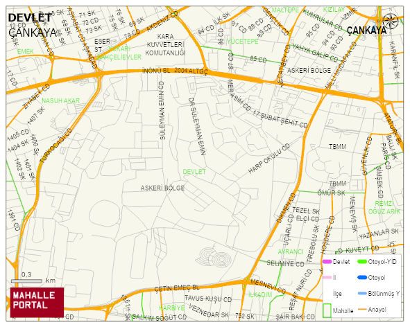
DEVLET Neighbourhood Digital Map | Updated Neighbourhood Map
DEVLET Neighbourhood – Population, Postal Code, Number of Workplaces
DEVLET neighborhood is located in ÇANKAYA district of ANKARA province. UAVT (National Address Database Code) Neighborhood Code: 1539. Postal Code: 6420. The population density is -per square kilometer- 1709 people. DEVLET 13 streets and avenues, 67 independent business licensed apartments, 697 residential licensed apartments, 482 households. 8769 people live in this settlement. 8037 male, 732 female. 60 and over is 37. The population rate of 60+ people is % 0 and the ratio of children under the age of 10 to the population is % 1