ESKIHAMAL Village Digital Map | Satellite View and Local Boundaries
Sivas ilinde,
Gürün ilçesinde, köyler içinde,
Hane adedi bakımından ilk sırada listesinde 5. Eskihamal sıralamada beşinci sırada yer almaktadır.
En çok yerleşim birimi barındıran listesinde 5. Eskihamal sıralamada beşinci sırada yer almaktadır.
Minik nüfusun en kalabalık olduğu listesinde 5. Eskihamal istatistiklere göre 5. sıradadır.
Emekli nüfusun merkezi listesinde 1. Eskihamal istatistiklere göre en üst sıradadır.
Sokak bakımından en kalabalık listesinde 5. Eskihamal sıralamada beşinci sırada yer almaktadır.
| Adi | ESKIHAMAL Province Affiliated | SIVAS District Affiliated | GÜRÜN Postal code | 58802 Number of Streets | 5 Population Density km2-people | 5.35 Number of Apartments with business Licenses | 5 Number of Apartments with Residential Licenses | 262 Number of Households / Families | 141 Total Population | 366 Male Population | 191 Woman Population | 175 Income Per Person - Spendable TL-Month | 4.621 |
|---|
ESKIHAMAL Village Map | Terrain and Topography
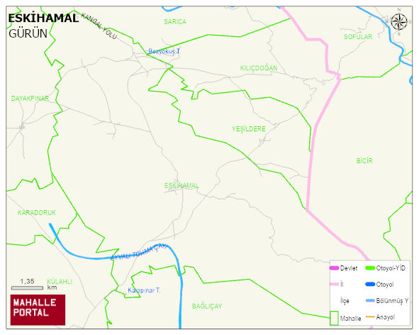
ESKIHAMAL Village Digital Map | Satellite View and Local Boundaries
ESKIHAMAL Village – Population, Postal Code, Number of Workplaces
ESKIHAMAL village GÜRÜN district of SIVAS province. UAVT (National Address Database Code) Village Code: 28917. Postal Code: 58802. ESKIHAMAL 5 streets and avenues, 3 independent business licensed apartments, 183 residential licensed apartments, 142 households. 382 people live in this settlement. 202 male, 180 female. 60 and over is 167. The population rate of 60+ people is % 43 and the ratio of children under the age of 10 to the population is % 4
Leave a Comment