ETILI Village Digital Map | Updated Neighbourhood Map
Çanakkale ilinde,
Çan ilçesinde, köyler içinde, En çok kişinin yaşadığı1. Etili sıralamada en üstte yer almaktadır.
En yüksek gelir seviyesine sahip listesinde 1. Etili istatistiklere göre en üst sıradadır.
En fazla hanenin yaşadığı listesinde 1. Etili istatistiklere göre en üst sıradadır.
Konut sayısının zirvede olduğu listesinde 1. Etili istatistiksel sıralamada tepede, 1. sıradadır.
İşyeri sayısında zirvede listesinde 2. Etili sıralamada ikinci sırada yer almaktadır.
En fazla ATM bulunan listesinde 1. Etili istatistiklere göre en üst sıradadır.
Çocuk nüfusu en yüksek listesinde 2. Etili sıralamada ikinci sırada yer almaktadır.
| Adi | ETILI Province Affiliated | ÇANAKKALE District Affiliated | ÇAN Postal code | 17402 Number of Streets | 1 Population Density km2-people | 130.59 Number of Apartments with business Licenses | 149 Number of Apartments with Residential Licenses | 982 Number of Households / Families | 466 Total Population | 1213 Male Population | 603 Woman Population | 610 Income Per Person - Spendable TL-Month | 10.521 |
|---|
ETILI Village Map | Updated Neighbourhood Map
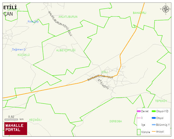
ETILI Village Digital Map | Updated Neighbourhood Map
ETILI Village – Population, Postal Code, Number of Workplaces
ETILI village ÇAN district of ÇANAKKALE province. UAVT (National Address Database Code) Village Code: 8361. Postal Code: 17402. ETILI 1 streets and avenues, 145 independent business licensed apartments, 981 residential licensed apartments, 467 households. 1239 people live in this settlement. 621 male, 618 female. 189 people have never married, 708 people are married, 43 people are divorced and 103 people have passed away. The number of people aged 60 and over is 287. The population rate of 60+ people is % 23 and the ratio of children under the age of 10 to the population is % 10 ÇAN -in the district- 9. the most crowded neighbourhood.
Leave a Comment