GÖKÇEAGAÇ Village Digital Map | Updated Neighbourhood Map
Çorum ilinde,
Uğurludağ ilçesinde, köyler içinde,
En geniş aile yerleşimi listesinde 4. Gökçeağaç sıralamada dördüncülük pozisyonundadır.
Mesken sayısı bakımından öne çıkan listesinde 3. Gökçeağaç sıralamada üçüncü sırada yer almaktadır.
Ticarî yoğunluk açısından önde listesinde 3. Gökçeağaç üçüncü konumda bulunan mahalledir.
Bekârlık oranı bakımından ilk sırada listesinde 4. Gökçeağaç dördüncü konumda bulunan mahalledir.
| Adi | GÖKÇEAGAÇ Province Affiliated | ÇORUM District Affiliated | UGURLUDAG Postal code | 19412 Number of Streets | 1 Population Density km2-people | 9.33 Number of Apartments with business Licenses | 3 Number of Apartments with Residential Licenses | 243 Number of Households / Families | 89 Total Population | 225 Male Population | 106 Woman Population | 119 Income Per Person - Spendable TL-Month | 5.694 |
|---|
GÖKÇEAGAÇ Village Map | All Neighbourhoods and Settlements
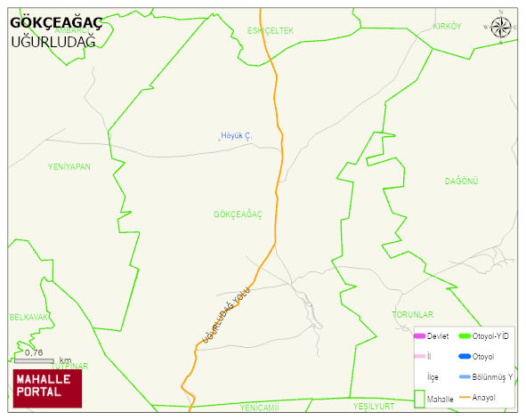
GÖKÇEAGAÇ Village Digital Map | Updated Neighbourhood Map
GÖKÇEAGAÇ Village – Population, Postal Code, Number of Workplaces
GÖKÇEAGAÇ village UGURLUDAG district of ÇORUM province. UAVT (National Address Database Code) Village Code: 9759. Postal Code: 19412. GÖKÇEAGAÇ 1 streets and avenues, 3 independent business licensed apartments, 242 residential licensed apartments, 96 households. 248 people live in this settlement. 124 male, 124 female.
Leave a Comment