GÜMÜSTEPE Village Digital Map | Mountains, Rivers and Elevation Details
Sivas ilinde,
Şarkışla ilçesinde, köyler içinde,
En yoğun nüfuslu listesinde 3. Gümüştepe sıralamada üçüncü sırada yer almaktadır.
Ev–hane sayısı en çok olan listesinde 4. Gümüştepe istatistik listelerinde dördüncü sırada bulunur.
Esnaf–işletme sayısı lider listesinde 4. Gümüştepe sıralamada dördüncü konumdadır.
Aile yapısının en genç olduğu listesinde 2. Gümüştepe sıralamada ikinci sırada yer almaktadır.
Kıdemli nüfusun en çok olduğu listesinde 4. Gümüştepe sıralamada dördüncü sıradadır.
| Adi | GÜMÜSTEPE Province Affiliated | SIVAS District Affiliated | SARKISLA Postal code | 58402 Number of Streets | 2 Population Density km2-people | 25.68 Number of Apartments with business Licenses | 28 Number of Apartments with Residential Licenses | 295 Number of Households / Families | 170 Total Population | 603 Male Population | 299 Woman Population | 304 Income Per Person - Spendable TL-Month | 4.761 |
|---|
GÜMÜSTEPE Village Map | Updated Neighbourhood Map
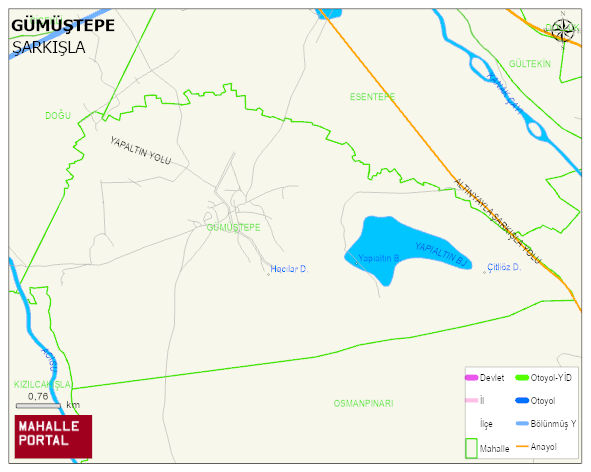
GÜMÜSTEPE Village Digital Map | Mountains, Rivers and Elevation Details
GÜMÜSTEPE Village – Population, Postal Code, Number of Workplaces
GÜMÜSTEPE village SARKISLA district of SIVAS province. UAVT (National Address Database Code) Village Code: 29414. Postal Code: 58402. GÜMÜSTEPE 2 streets and avenues, 25 independent business licensed apartments, 221 residential licensed apartments, 170 households. 637 people live in this settlement. 320 male, 317 female. 129 people have never married, 331 people are married, 20 people are divorced and 39 people have passed away. The number of people aged 60 and over is 144. The population rate of 60+ people is % 22 and the ratio of children under the age of 10 to the population is % 10
Leave a Comment