HATUNOGLU Village Digital Map | Interactive Neighbourhoods
Kırşehir ilinde,
Boztepe ilçesinde, köyler içinde,
Hane nüfusunun en kalabalık olduğu listesinde 4. Hatunoğlu 4. sırada konumlanmış, öne çıkan bir yerleşimdir.
Mesken adedi lider listesinde 5. Hatunoğlu sıralamada beşinci sırada yer almaktadır.
İş potansiyeli en yüksek listesinde 5. Hatunoğlu sıralamada beşinci sırada yer almaktadır.
Single yaşam oranı yüksek listesinde 5. Hatunoğlu sıralamada beşinci sırada yer almaktadır.
Sokak çeşitliliği lider listesinde 3. Hatunoğlu listede üçüncü sırada olmasıyla bilinir.
| Adi | HATUNOGLU Province Affiliated | KIRSEHIR District Affiliated | BOZTEPE Postal code | 40060 Number of Streets | 2 Population Density km2-people | 4.84 Number of Apartments with business Licenses | 15 Number of Apartments with Residential Licenses | 102 Number of Households / Families | 64 Total Population | 162 Male Population | 84 Woman Population | 78 Income Per Person - Spendable TL-Month | 5.528 |
|---|
HATUNOGLU Village Map | Interactive Neighbourhoods
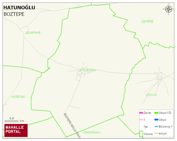
HATUNOGLU Village Digital Map | Interactive Neighbourhoods
HATUNOGLU Village – Population, Postal Code, Number of Workplaces
HATUNOGLU village BOZTEPE district of KIRSEHIR province. UAVT (National Address Database Code) Village Code: 19785. Postal Code: 40060. HATUNOGLU 2 streets and avenues, 12 independent business licensed apartments, 101 residential licensed apartments, 68 households. 179 people live in this settlement. 94 male, 85 female. BOZTEPE -in the district- 9. the most crowded neighbourhood.
Leave a Comment