TOP 10: NÜFUS
Konya ilinde,
Sarayönü ilçesinde, mahalleler içinde,
En çok yerleşim birimi barındıran listesinde 5. Kadıoğlu sıralamada beşinci sırada yer almaktadır.
Eğitim seviyesinde alt sıralarda listesinde 5. Kadıoğlu istatistik listelerinde beşinci basamakta yer alır.
Para çekme noktalarının merkezi listesinde 3. Kadıoğlu sıralamada üçüncü sırada yer almaktadır.
Bekar hane oranı yüksek listesinde 3. Kadıoğlu kayıtlarda 3. sırada yer almıştır.
Sokak bakımından en kalabalık listesinde 4. Kadıoğlu yer alır.
| Adi | KADIOGLU Province Affiliated | KONYA District Affiliated | SARAYÖNÜ Postal code | 42440 Number of Streets | 89 Population Density km2-people | 8.44 Number of Apartments with business Licenses | 59 Number of Apartments with Residential Licenses | 639 Number of Households / Families | 286 Total Population | 806 Male Population | 436 Woman Population | 370 Income Per Person - Spendable TL-Month | 6.366 |
|---|
KADIOGLU Neighbourhood Map | Boundaries of Villages
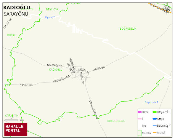
KADIOGLU Neighbourhood Digital Map | Updated Neighbourhood Map
KADIOGLU Neighbourhood – Population, Postal Code, Number of Workplaces
KADIOGLU neighborhood is located in SARAYÖNÜ district of KONYA province. UAVT (National Address Database Code) Neighborhood Code: 196157. Postal Code: 42440. The population density is -per square kilometer- 8 people. KADIOGLU 88 streets and avenues, 58 independent business licensed apartments, 638 residential licensed apartments, 296 households. 839 people live in this settlement. 451 male, 388 female. 160 people have never married, 463 people are married, 47 people are divorced and 32 people have passed away. The number of people aged 60 and over is 170. The population rate of 60+ people is % 20 and the ratio of children under the age of 10 to the population is % 9 SARAYÖNÜ -in the district- 9. the most crowded neighbourhood.