KARALARGÜNEY Village Digital Map | Mountains, Rivers and Elevation Details
Çorum ilinde,
Osmancık ilçesinde, köyler içinde,
Ekonomik refahın merkezi listesinde 4. Karalargüney sıralamada dördüncülük pozisyonundadır.
Gelir seviyesi yüksek bireylerin merkezi listesinde 3. Karalargüney şehir içi sıralamada 3. sıradadır.
Osmancık ilçesinde, köyler içinde,
Ekonomik refahın merkezi listesinde 4. Karalargüney sıralamada dördüncülük pozisyonundadır.
Gelir seviyesi yüksek bireylerin merkezi listesinde 3. Karalargüney şehir içi sıralamada 3. sıradadır.
| Adi | KARALARGÜNEY Province Affiliated | ÇORUM District Affiliated | OSMANCIK Postal code | 19502 Number of Streets | 4 Population Density km2-people | 16.25 Number of Apartments with business Licenses | 5 Number of Apartments with Residential Licenses | 480 Number of Households / Families | 200 Total Population | 429 Male Population | 198 Woman Population | 231 Income Per Person - Spendable TL-Month | 6.824 |
|---|
KARALARGÜNEY Village Map | Boundaries of Villages
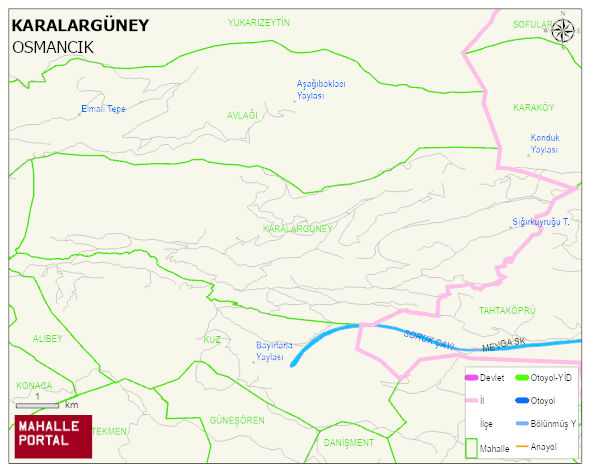
KARALARGÜNEY Village Digital Map | Mountains, Rivers and Elevation Details
KARALARGÜNEY Village – Population, Postal Code, Number of Workplaces
KARALARGÜNEY village OSMANCIK district of ÇORUM province. UAVT (National Address Database Code) Village Code: 9638. Postal Code: 19502. KARALARGÜNEY 4 streets and avenues, 5 independent business licensed apartments, 477 residential licensed apartments, 211 households. 492 people live in this settlement. 231 male, 261 female. 60 and over is 264. The population rate of 60+ people is % 53 En yasli 600 mahalle ve köyden biridir. (Nüfusu 250den büyük 29000 köy ve mahalle içinde)
Leave a Comment