TOP 10: NÜFUS
İstanbul ilinde,
Bakırköy ilçesinde, mahalleler içinde,
Nüfus bakımından önde gelen listesinde 1. Kartaltepe istatistiksel olarak ilk sıradadır.
Hane adedi bakımından ilk sırada listesinde 1. Kartaltepe istatistiklere göre 1. sırada yer almaktadır.
En çok yerleşim birimi barındıran listesinde 1. Kartaltepe yer alır.
Ekonomik faaliyetlerin merkezi listesinde 5. Kartaltepe beşinci konumda bulunan mahalledir.
Sokak bakımından en kalabalık listesinde 3. Kartaltepe kayıtlarda üçüncü sırada gözükür.
| Adi | KARTALTEPE Province Affiliated | ISTANBUL District Affiliated | BAKIRKÖY Postal code | 34145 Number of Streets | 96 Population Density km2-people | 25845.99 Number of Apartments with business Licenses | 2064 Number of Apartments with Residential Licenses | 16555 Number of Households / Families | 12753 Total Population | 34866 Male Population | 16140 Woman Population | 18726 Income Per Person - Spendable TL-Month | 46.195 |
|---|
KARTALTEPE Neighbourhood Map | Geography and Natural Features
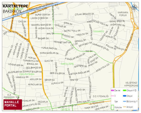
KARTALTEPE Neighbourhood Digital Map | Terrain and Topography
KARTALTEPE Neighbourhood – Population, Postal Code, Number of Workplaces
KARTALTEPE neighborhood is located in BAKIRKÖY district of ISTANBUL province. UAVT (National Address Database Code) Neighborhood Code: 40197. Postal Code: 34145. The population density is -per square kilometer- 25804 people. KARTALTEPE 96 streets and avenues, 2094 independent business licensed apartments, 16623 residential licensed apartments, 12684 households. 34831 people live in this settlement. 16119 male, 18712 female. 9213 people have never married, 16125 people are married, 2656 people are divorced and 2212 people have passed away. The number of people aged 60 and over is 8134. The population rate of 60+ people is % 23 and the ratio of children under the age of 10 to the population is % 8 BAKIRKÖY -in the district- 1. the most crowded neighbourhood.