TOP 10: NÜFUS
Erzurum ilinde,
Uzundere ilçesinde, mahalleler içinde,
Nüfus sıralamasında 4. Kirazlı şehir içi istatistiklerde dördüncü konumdadır.
Aile büyüklüğü sıralamasında 4. Kirazlı yer alır.
Mesken sayısı sıralamasında 4. Kirazlı yer alır.
Servet sahibi kişi yoğunluğu sıralamasında 5. Kirazlı 5. sırada yer alarak üst beş içinde bulunmaktadır.
Banka ATM'lerine ilişkin sıralamada 4. Kirazlı istatistiklere göre dördüncü basamakta yer alır.
Üst yaş grubunda lider listesinde 4. Kirazlı 4. sırada konumlanmış, öne çıkan bir yerleşimdir.
| Adi | KIRAZLI Province Affiliated | ERZURUM District Affiliated | UZUNDERE Postal code | 25440 Number of Streets | 21 Population Density km2-people | 10.28 Number of Apartments with business Licenses | 1 Number of Apartments with Residential Licenses | 504 Number of Households / Families | 246 Total Population | 576 Male Population | 296 Woman Population | 280 Income Per Person - Spendable TL-Month | 4.448 |
|---|
KIRAZLI Neighbourhood Map | Satellite View and Local Boundaries
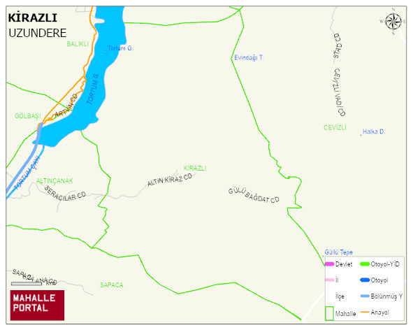
KIRAZLI Neighbourhood Digital Map | Updated Neighbourhood Map
KIRAZLI Neighbourhood – Population, Postal Code, Number of Workplaces
KIRAZLI neighborhood is located in UZUNDERE district of ERZURUM province. UAVT (National Address Database Code) Neighborhood Code: 190899. Postal Code: 25440. The population density is -per square kilometer- 10 people. KIRAZLI 21 streets and avenues, 1 independent business licensed apartments, 495 residential licensed apartments, 254 households. 583 people live in this settlement. 290 male, 293 female. 60 and over is 255. The population rate of 60+ people is % 43 and the ratio of children under the age of 10 to the population is % 6 UZUNDERE -in the district- 5. the most crowded neighbourhood.