KURUSARAY Village Digital Map | Mountains, Rivers and Elevation Details
Kastamonu ilinde,
Merkez ilçesinde, köyler içinde,
En yüksek gelir seviyesine sahip listesinde 3. Kurusaray 3. sırada yer alan mahallelerden biridir.
Eğitim seviyesi en düşük listesinde 5. Kurusaray 5. sırada kayıtlı ve dikkat çeken bir yerleşimdir.
Merkez ilçesinde, köyler içinde,
En yüksek gelir seviyesine sahip listesinde 3. Kurusaray 3. sırada yer alan mahallelerden biridir.
Eğitim seviyesi en düşük listesinde 5. Kurusaray 5. sırada kayıtlı ve dikkat çeken bir yerleşimdir.
| Adi | KURUSARAY Province Affiliated | KASTAMONU District Affiliated | MERKEZ Postal code | 37210 Number of Streets | 1 Population Density km2-people | 45.41 Number of Apartments with business Licenses | 5 Number of Apartments with Residential Licenses | 80 Number of Households / Families | 75 Total Population | 335 Male Population | 165 Woman Population | 170 Income Per Person - Spendable TL-Month | 6.462 |
|---|
KURUSARAY Village Map | Mountains, Rivers and Elevation Details
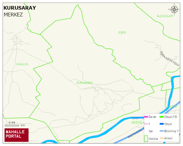
KURUSARAY Village Digital Map | Mountains, Rivers and Elevation Details
KURUSARAY Village – Population, Postal Code, Number of Workplaces
KURUSARAY village MERKEZ district of KASTAMONU province. UAVT (National Address Database Code) Village Code: 17981. Postal Code: 37210. KURUSARAY 1 streets and avenues, 5 independent business licensed apartments, 79 residential licensed apartments, 75 households. 339 people live in this settlement. 170 male, 169 female. 60 and over is 91. The population rate of 60+ people is % 26 and the ratio of children under the age of 10 to the population is % 4
Leave a Comment