KUSURA Village Digital Map | Mountains, Rivers and Elevation Details
Afyonkarahisar ilinde,
Sandıklı ilçesinde, köyler içinde,
Nüfus yoğunluğu en fazla listesinde 3. Kusura istatistiklere göre 3. sıradadır.
Ekonomik refahın merkezi listesinde 3. Kusura 3. sırada kayıtlı olan önemli bir yerleşimdir.
İşletme sayısı en kalabalık listesinde 5. Kusura kayıtlarda 5. sırada gözükmektedir.
Bağımsız yaşayan nüfusta lider listesinde 5. Kusura sıralamada beşinci sırada yer almaktadır.
Doğurganlık etkisi yüksek listesinde 2. Kusura kayda geçen sıralamada ikinci konumdadır.
Mahalle içi yol/sokak sayısı zirvede listesinde 4. Kusura sıralamada dördüncülük pozisyonundadır.
| Adi | KUSURA Province Affiliated | AFYONKARAHISAR District Affiliated | SANDIKLI Postal code | 03502 Number of Streets | 47 Population Density km2-people | 25.05 Number of Apartments with business Licenses | 81 Number of Apartments with Residential Licenses | 567 Number of Households / Families | 215 Total Population | 795 Male Population | 407 Woman Population | 388 Income Per Person - Spendable TL-Month | 7.591 |
|---|
KUSURA Village Map | Boundaries of Villages
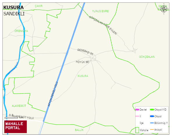
KUSURA Village Digital Map | Mountains, Rivers and Elevation Details
KUSURA Village – Population, Postal Code, Number of Workplaces
KUSURA village SANDIKLI district of AFYONKARAHISAR province. UAVT (National Address Database Code) Village Code: 1348. Postal Code: 3502. KUSURA 47 streets and avenues, 80 independent business licensed apartments, 564 residential licensed apartments, 217 households. 803 people live in this settlement. 414 male, 389 female. 157 people have never married, 429 people are married, 16 people are divorced and 63 people have passed away. The number of people aged 60 and over is 163. The population rate of 60+ people is % 20 and the ratio of children under the age of 10 to the population is % 10
Leave a Comment