KUTLUCA Village Digital Map | Mountains, Rivers and Elevation Details
Adıyaman ilinde,
Besni ilçesinde, köyler içinde,
Nüfus açısından zirvede yer alan listesinde 5. Kutluca sıralamada beşinci sırada yer almaktadır.
Aile yaşamının en yoğun olduğu listesinde 5. Kutluca 5. sırada olmasıyla öne çıkar.
Dükkan ve işyeri bakımından ilk sırada listesinde 2. Kutluca 2. sırada, bölgenin önde gelen yerleşimlerinden biridir.
| Adi | KUTLUCA Province Affiliated | ADIYAMAN District Affiliated | BESNI Postal code | 02320 Number of Streets | 2 Population Density km2-people | 27.53 Number of Apartments with business Licenses | 125 Number of Apartments with Residential Licenses | 338 Number of Households / Families | 245 Total Population | 883 Male Population | 449 Woman Population | 434 Income Per Person - Spendable TL-Month | 5.475 |
|---|
KUTLUCA Village Map | Boundaries of Villages
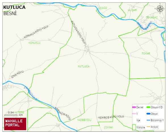
KUTLUCA Village Digital Map | Mountains, Rivers and Elevation Details
KUTLUCA Village – Population, Postal Code, Number of Workplaces
KUTLUCA village BESNI district of ADIYAMAN province. UAVT (National Address Database Code) Village Code: 686. Postal Code: 2320. KUTLUCA 2 streets and avenues, 30 independent business licensed apartments, 335 residential licensed apartments, 250 households. 921 people live in this settlement. 470 male, 451 female. 60 and over is 173. The population rate of 60+ people is % 18 and the ratio of children under the age of 10 to the population is % 12
Leave a Comment