TOP 10: NÜFUS
İstanbul ilinde,
Şile ilçesinde, mahalleler içinde,
Nüfus sıralamasında 4. Meşrutiyet sıralamada dördüncülük pozisyonundadır.
Gelir düzeyi sıralamasında 4. Meşrutiyet yer alır.
Servet sahibi kişi yoğunluğu sıralamasında 5. Meşrutiyet sıralamada beşinci sırada yer almaktadır.
Banka ATM'lerine ilişkin sıralamada 5. Meşrutiyet sıralamada beşinci sırada yer almaktadır.
Bekârlık oranı sıralamasında 1. Meşrutiyet sıralamada birinci olarak kayda geçmiştir.
Aile içindeki genç oranı sıralamasında 4. Meşrutiyet yer alır.
| Adi | MESRUTIYET Province Affiliated | ISTANBUL District Affiliated | SILE Postal code | 34983 Number of Streets | 41 Population Density km2-people | 696.16 Number of Apartments with business Licenses | 20 Number of Apartments with Residential Licenses | 1134 Number of Households / Families | 379 Total Population | 2257 Male Population | 1133 Woman Population | 1124 Income Per Person - Spendable TL-Month | 20.439 |
|---|
MESRUTIYET Neighbourhood Map | Boundaries of Villages
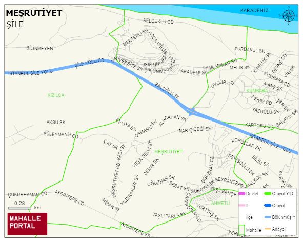
MESRUTIYET Neighbourhood Digital Map | Updated Neighbourhood Map
MESRUTIYET Neighbourhood – Population, Postal Code, Number of Workplaces
MESRUTIYET neighborhood is located in SILE district of ISTANBUL province. UAVT (National Address Database Code) Neighborhood Code: 191889. Postal Code: 34983. The population density is -per square kilometer- 745 people. MESRUTIYET 41 streets and avenues, 19 independent business licensed apartments, 1118 residential licensed apartments, 350 households. 2420 people live in this settlement. 1224 male, 1196 female. 1741 people have never married, 454 people are married, 39 people are divorced and 30 people have passed away. The number of people aged 60 and over is 143. The population rate of 60+ people is % 5 and the ratio of children under the age of 10 to the population is % 4 SILE -in the district- 4. the most crowded neighbourhood.