TOP 10: NÜFUS
Şanlıurfa ilinde,
Karaköprü ilçesinde, mahalleler içinde,
Nüfus açısından zirvede yer alan listesinde 5. Narlıkuyu listede beşinci sırada yer almaktadır.
Aile yaşamının en yoğun olduğu listesinde 5. Narlıkuyu sıralamada beşinci sırada yer almaktadır.
Konut kapasitesi en geniş listesinde 5. Narlıkuyu istatistiksel olarak yer alır.
Ekonomik açıdan en güçlü kitle listesinde 1. Narlıkuyu bölge sıralamasında birinci sıradadır.
| Adi | NARLIKUYU Province Affiliated | SANLIURFA District Affiliated | KARAKÖPRÜ Postal code | 63320 Number of Streets | 70 Population Density km2-people | 16260.23 Number of Apartments with business Licenses | 380 Number of Apartments with Residential Licenses | 8601 Number of Households / Families | 6029 Total Population | 22280 Male Population | 11057 Woman Population | 11223 Income Per Person - Spendable TL-Month | 19.529 |
|---|
NARLIKUYU Neighbourhood Map | Mountains, Rivers and Elevation Details
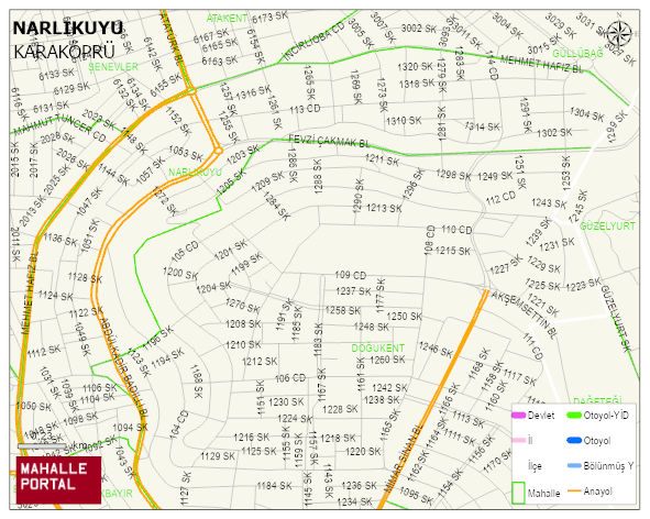
NARLIKUYU Neighbourhood Digital Map | Interactive Neighbourhoods
NARLIKUYU Neighbourhood – Population, Postal Code, Number of Workplaces
NARLIKUYU neighborhood is located in KARAKÖPRÜ district of SANLIURFA province. UAVT (National Address Database Code) Neighborhood Code: 180786. Postal Code: 63320. The population density is -per square kilometer- 15578 people. NARLIKUYU 70 streets and avenues, 338 independent business licensed apartments, 7937 residential licensed apartments, 5677 households. 21354 people live in this settlement. 10670 male, 10684 female. 4434 people have never married, 9522 people are married, 322 people are divorced and 427 people have passed away. The number of people aged 60 and over is 1409. The population rate of 60+ people is % 6 and the ratio of children under the age of 10 to the population is % 21 KARAKÖPRÜ -in the district- 5. the most crowded neighbourhood.