ÖRENSAR Village Digital Map | Satellite View and Local Boundaries
Gümüşhane ilinde, köyler içinde,
Ekonomik refahın merkezi listesinde 5. Örenşar güçlü gelir performansıyla öne çıktı.
Köse ilçesinde, köyler içinde,
Ekonomik refahın merkezi listesinde 1. Örenşar birinci konumda, en üstte bulunan mahalledir.
İşletme sayısı en kalabalık listesinde 2. Örenşar 2. sırada, bölgenin önde gelen yerleşimlerinden biridir.
Öğretim düzeyi gelişmeye açık listesinde 2. Örenşar istatistiklere göre 2. sıradadır.
Akademik düzeyi güçlü olan listesinde 3. Örenşar sıralamada üçüncü basamakta yer alır.
Gelir seviyesi yüksek bireylerin merkezi listesinde 1. Örenşar istatistiklere göre en üst sıradadır.
| Adi | ÖRENSAR Province Affiliated | GÜMÜSHANE District Affiliated | KÖSE Postal code | 29652 Number of Streets | 1 Population Density km2-people | 3.40 Number of Apartments with business Licenses | 6 Number of Apartments with Residential Licenses | 105 Number of Households / Families | 36 Total Population | 107 Male Population | 60 Woman Population | 47 Income Per Person - Spendable TL-Month | 9.867 |
|---|
ÖRENSAR Village Map | Updated Neighbourhood Map
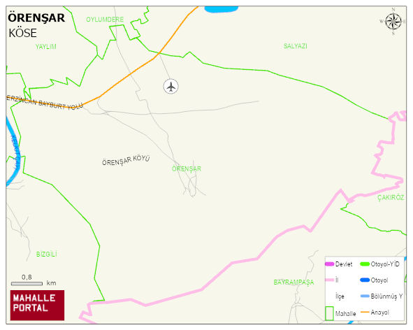
ÖRENSAR Village Digital Map | Satellite View and Local Boundaries
ÖRENSAR Village – Population, Postal Code, Number of Workplaces
ÖRENSAR village KÖSE district of GÜMÜSHANE province. UAVT (National Address Database Code) Village Code: 15088. Postal Code: 29652. ÖRENSAR 1 streets and avenues, 4 independent business licensed apartments, 105 residential licensed apartments, 41 households. 256 people live in this settlement. 136 male, 120 female. 60 and over is 59. The population rate of 60+ people is % 23 and the ratio of children under the age of 10 to the population is % 5
Leave a Comment