İlçedeki Nüfusu En Yüksek Yerleşimler
SAFRANBOLU, KARABÜK
| Name | SAFRANBOLU |
|---|---|
| Province Affiliated | KARABÜK |
| City Plate code | 78 |
| Population Density km2-people | 85,35 |
| Number of Apartments with business Licenses | 4.338 |
| Number of Apartments with Residential Licenses | 35.527 |
| Number of Households / Families | 22.926 |
| Average Household Size | 2,72 |
| Total Population | 69.441 |
| Foreigner Population | 937 |
| Area km2 | 813,56 |
SAFRANBOLU, KARABÜK Digital Map | Updated District and Neighbourhood Map
Safranbolu ilçesinde 21 mahalle bulunmaktadır.
| 15 TEMMUZ | AKÇASU | AŞAĞI TOKATLI | ATATÜRK |
| BABASULTAN | BAĞLARBAŞI | BARIŞ | CAMİKEBİR |
| CEMALCAYMAZ | ÇAVUŞ | ÇEŞME | EMEK |
| ESENTEPE | HACIHALİL | HÜSEYİNÇELEBİ | İSMETPAŞA |
Tümünü Göster (21)
| İZZETPAŞA | KARAALİ | KİRKİLLE | MUSALLA |
| YENİMAHALLE |
SAFRANBOLU, KARABÜK Digital Map | Updated District and Neighbourhood Map
Safranbolu ilçesine bağlı 60 köy bulunmaktadır.
Köyler
| AĞAÇKESE | AKKIŞLA | AKÖREN | ALÖREN |
| AŞAĞIÇİFTLİK | AŞAĞIDANA | AŞAĞIGÜNEY | BAĞCIĞAZ |
| BOSTANBÜKÜ | CABBAR | CÜCAHLI | ÇATAK |
| ÇAVUŞLAR | ÇERÇEN | ÇIRAKLAR | DANİŞMENT |
Tümünü Göster (60)
SAFRANBOLU, KARABÜK Digital Map | Updated District and Neighbourhood Map
Economic wealth center
Most densely populated with businesses
Where most university graduates live
Highest m² land value
Top among older age group
Most ATMs present
Leader in household density
Largest housing capacity
Limited educational opportunities
Highest single ratio
High rate of single adults
Widest settlement network
Top among upper income group
Highest child population
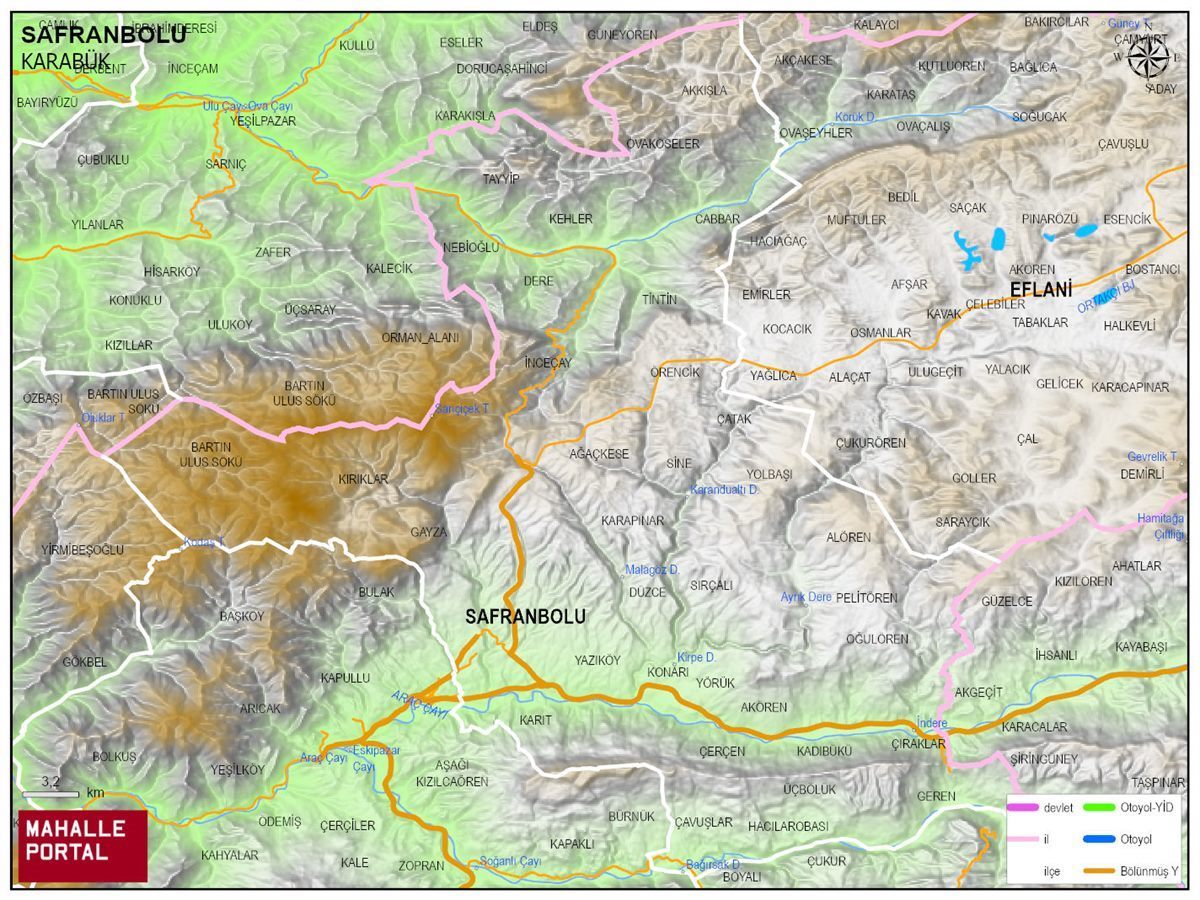
SAFRANBOLU Physical Map | District Terrain and Topography
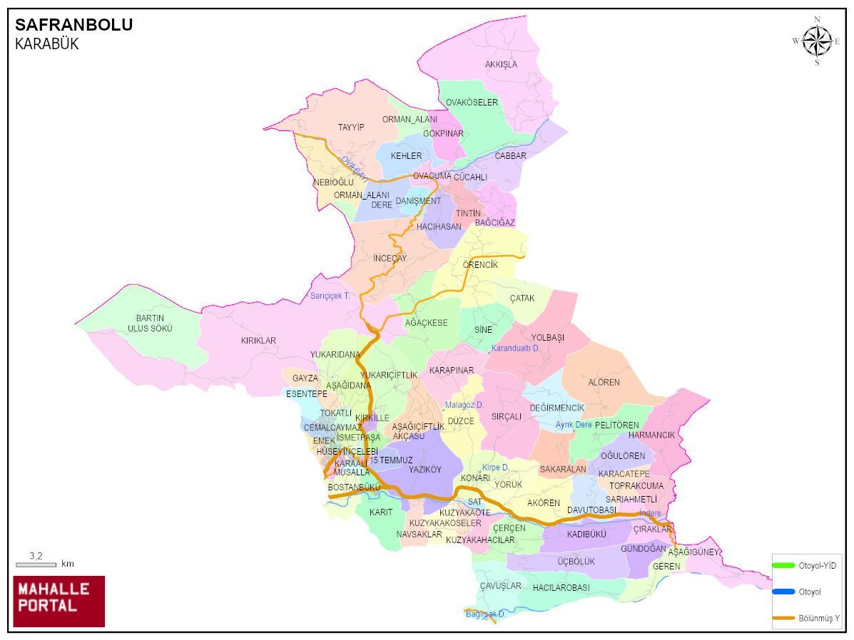
SAFRANBOLU Neighbourhood Map | All Neighbourhoods and Settlements
SAFRANBOLU Population and Family Structure
| District Center Population | 51.911 |
|---|---|
| Town and Village Population | 18.132 |
| Male Population | 35.847 |
| Female Population | 34.196 |
| Average Age | 36 |
| Average Age of Males | 33 |
| Average Age of Females | 39 |
| Number of Household Members | 22.672 |
| Average Household Size | 2 |
| Number of Single Person Households | 4.899 |
| Number of Nuclear Family Households | 14.615 |
| Number of Large Family Households | 2.643 |
| Number of Non-Nuclear Family Households | 515 |
SAFRANBOLU Artificial Intelligence Comments for
SAFRANBOLU is a district of KARABÜK province. The population is 70043, the number of streets is 807, the number of apartments with housing licenses is 35240 and the number of independent businesses with business licenses is 4295. The average age is calculated as 36, 33 for men and 39 for women. 18481 people have never married, 34163 people are married, 3849 people of (wife - husband) have passed away, and 2218 people are divorced. The average household size of the district is 2, Tek kisinin yasadigi hane sayisi 4899, and the number of nuclear family households is 14615.
Leave a Comment
NEIGHBORHOODS
VILLAGES
OVAKÖSELER
TİNTİN
HACIHASAN
DANİŞMENT
AKKIŞLA
CABBAR
GAYZA
KADIBÜKÜ
KARACATEPE
KARAPINAR
KARIT
KIRIKLAR
KONARI
KUZYAKAHACILAR
KUZYAKAKÖSELER
KUZYAKAÖTE
NAVSAKLAR
OĞULÖREN
ÖRENCİK
PELİTÖREN
SAKARALAN
SARIAHMETLİ
SAT
SIRÇALI
TOKATLI
TOPRAKCUMA
ÜÇBÖLÜK
YAZIKÖY
YOLBAŞI
YÖRÜK
YUKARIÇİFTLİK
YUKARIDANA
AŞAĞIGÜNEY
OVACUMA
BAĞCIĞAZ
CÜCAHLI
DERE
GÖKPINAR
İNCEÇAY
KEHLER
NEBİOĞLU
TAYYİP
AĞAÇKESE
AKÖREN
ALÖREN
ÇATAK
AŞAĞIÇİFTLİK
AŞAĞIDANA
BOSTANBÜKÜ
SİNE
ÇAVUŞLAR
ÇERÇEN
ÇIRAKLAR
DAVUTOBASI
DEĞİRMENCİK
DÜZCE
GEREN
GÜNDOĞAN
HACILAROBASI
HARMANCIK