TOP 10: NÜFUS
Ordu ilinde,
Aybastı ilçesinde, mahalleler içinde,
Arsa fiyatlarında lider listesinde 3. Sağlık şehir içi sıralamada 3. sıradadır.
En fazla yüksek gelirli yaşayan listesinde 5. Sağlık beşinci konumda bulunan mahalledir.
Finans erişimi en geniş olan listesinde 5. Sağlık sıralamada beşinci sırada yer almaktadır.
Eşi vefat edenlerin en yoğun olduğu listesinde 5. Sağlık 5. sırada yer alarak üst beş içinde bulunmaktadır.
| Adi | SAGLIK Province Affiliated | ORDU District Affiliated | AYBASTI Postal code | 52500 Number of Streets | 4 Population Density km2-people | 264.31 Number of Apartments with business Licenses | 15 Number of Apartments with Residential Licenses | 428 Number of Households / Families | 216 Total Population | 593 Male Population | 305 Woman Population | 288 Income Per Person - Spendable TL-Month | 13.250 |
|---|
SAGLIK Neighbourhood Map | Boundaries of Villages
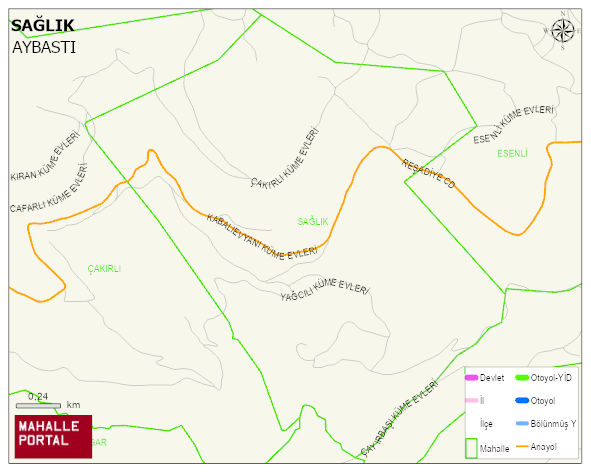
SAGLIK Neighbourhood Digital Map | Satellite View and Local Boundaries
SAGLIK Neighbourhood – Population, Postal Code, Number of Workplaces
SAGLIK neighborhood is located in AYBASTI district of ORDU province. UAVT (National Address Database Code) Neighborhood Code: 60883. Postal Code: 52500. The population density is -per square kilometer- 277 people. SAGLIK 4 streets and avenues, 14 independent business licensed apartments, 419 residential licensed apartments, 226 households. 622 people live in this settlement. 314 male, 308 female. 60 and over is 181. The population rate of 60+ people is % 29 and the ratio of children under the age of 10 to the population is % 8