İlçedeki Nüfusu En Yüksek Yerleşimler
VIRANSEHIR, SANLIURFA
| Name | VIRANSEHIR |
|---|---|
| Province Affiliated | SANLIURFA |
| City Plate code | 63 |
| Population Density km2-people | 102,76 |
| Number of Apartments with business Licenses | 13.081 |
| Number of Apartments with Residential Licenses | 66.563 |
| Number of Households / Families | 42.910 |
| Average Household Size | 4,93 |
| Total Population | 213.352 |
| Foreigner Population | 813 |
| Area km2 | 2.076,23 |
VIRANSEHIR, SANLIURFA Digital Map | Updated District and Neighbourhood Map
Viranşehir ilçesinde 148 mahalle bulunmaktadır.
| ABALAR | ADAKÖY | AKÇATAŞ | AKKESE |
| ALAKONAK | ALTINBAŞAK | ANIT | ARISU |
| ARITIR | ASLANBABA | AŞAĞITINAZ | ATATÜRK |
| ATICILAR | AYAKLI | AYRIDÜŞEN | AZADİ |
Tümünü Göster (148)
VIRANSEHIR, SANLIURFA Digital Map | Updated District and Neighbourhood Map
Highest economic power
Leader in number of trades and businesses
Where most university graduates live
Highest m² land value
High elderly ratio
Strong financial service accessibility
Most active family life
Largest housing capacity
Limited educational opportunities
Leader in independent living
Peak widow rate
Having a strong street network
Leader in number of wealthy people
High fertility influence
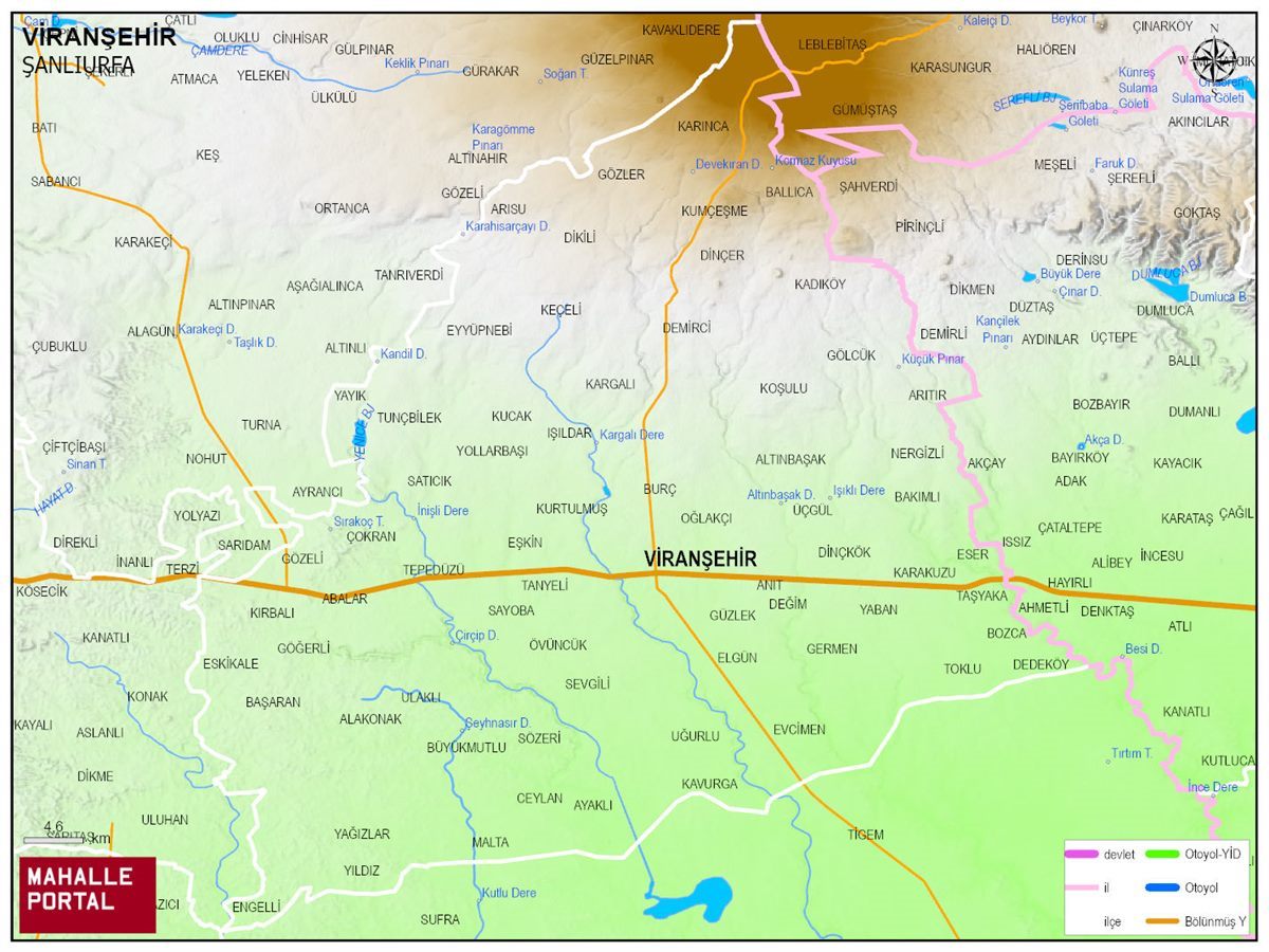
VIRANSEHIR Physical Map | District Terrain and Topography
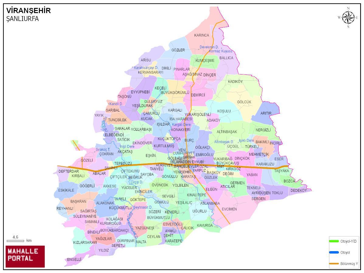
VIRANSEHIR Neighbourhood Map | All Neighbourhoods and Settlements
VIRANSEHIR Population and Family Structure
| District Center Population | 211.065 |
|---|---|
| Town and Village Population | 0 |
| Male Population | 104.816 |
| Female Population | 106.249 |
| Average Age | 20 |
| Average Age of Males | 19 |
| Average Age of Females | 20 |
| Number of Household Members | 42.353 |
| Average Household Size | 4 |
| Number of Single Person Households | 5.264 |
| Number of Nuclear Family Households | 30.376 |
| Number of Large Family Households | 5.880 |
| Number of Non-Nuclear Family Households | 833 |
VIRANSEHIR Artificial Intelligence Comments for
VIRANSEHIR is a district of SANLIURFA province. The population is 211065, the number of streets is 1571, the number of apartments with housing licenses is 64855 and the number of independent businesses with business licenses is 12759. The average age is calculated as 20, 19 for men and 20 for women. 49265 people have never married, 74108 people are married, 3531 people of (wife - husband) have passed away, and 1404 people are divorced. The average household size of the district is 4, Tek kisinin yasadigi hane sayisi 5264, and the number of nuclear family households is 30376.
Leave a Comment
NEIGHBORHOODS
ÇALICIK
ATATÜRK
BAHÇELİEVLER
CUMHURİYET
ŞIRNAK
EMİROĞLU
AZADİ
GÖLBAŞI
HÜRRİYET
KALE
YENİŞEHİR
KIŞLA
ÖZAL
SELAHADDİN EYYUBİ
ŞARKPINAR
TEKKE
YENİ
KURUROĞLU
SEVGİLİ
İSA HARABESİ
SERGEN
ESVETOĞLU
ATICILAR
CEYLAN
BAŞKÖY
KIZLARSARAYI
ŞEHİT
AYRIDÜŞEN
ANIT
KARATEPE
SAKALAR
BALLICA
BÜYÜKGÖRÜMLÜ
DİKİLİ
DİNÇER
GÖLCÜK
GÖZLER
KADIKÖY
KARINCA
KOŞULU
KUMÇEŞME
PINARLAR
GÖĞERLİ
EYYÜPNEBİ
ADAKÖY
AKÇATAŞ
AKKESE
ALAKONAK
ALTINBAŞAK
ARISU
ASLANBABA
AYAKLI
BAKIMLI
BAŞARAN
BEĞRÜK
BİNEKLİ
BOZCA
BURÇ
BÜYÜKBARDAKÇI
BÜYÜKMUTLU
ÇAMURLU
ÇİFTÇİLER
ÇİFTEKUYU
ÇOKRAN
DEDEKÖY
DEFTERDAR
DEĞİM
DİNÇKÖK
EKİNDÖVER
ELBEĞENDİ
ELGÜN
ENGELLİ
ESER
ESKİKALE
EŞKİN
EVCİMEN
GERMEN
GÖKTEPE
GÖMÜLÜ
GÖNÜLLÜ
GÖZELİ
GÜLERYÜZ
GÜRPINAR
GÜZLEK
IŞILDAR
İNCİRLİ
KARAKUZU
KARATAŞ
KARGALI
KAVURGA
KEÇELİ
KEMERLİ
KERVANSARAYI
KINALITEPE
KIRBALI
KIRKGÖZ
ABALAR
KOLAĞASI
KONAKYERİ
KUCAK
KURTULMUŞ
REYHANLI
KÜÇÜKMUTLU
KÜÇÜKTOPÇA
MALTA
MEHMETÇİK
NERGİZLİ
OĞLAKÇI
ÖVÜNCÜK
SAĞIRTAŞ
SARIBAL
SATICIK
SAYOBA
SÖZERİ
SÜLEYMANİYE
ŞAHİNLİ
TANYELİ
TAŞÖNÜ
TAŞYAKA
TEKNELİ
TEPEDÜZÜ
TOKLU
TUNÇBİLEK
TÜRKELİ
ULAKLI
ÜÇGÜL
YABAN
YAĞIZLAR
YARPUZ
YAYIK
YAZGÜNEŞİ
YEŞİLALIÇ
YEŞİLDURAK
YILDIZ
YOLBİLEN
YOLLARBAŞI
YUKARIBAĞ
YÜCELER
BÜYÜKÇAVUŞ
SEPETLİ
YUKARIDİLİMLİ
YUKARIŞÖLENLİ
SAMANLI
ARITIR
EKİNCİLER
UĞURLU
DEMİRCİ
AŞAĞITINAZ