KARABURUN Village Digital Map | All Neighbourhoods and Settlements
Adıyaman ilinde,
Gölbaşı ilçesinde, köyler içinde,
Kalabalığıyla öne çıkan listesinde 2. Karaburun sıralamada ikincilik konumunu korumaktadır.
Hane nüfusunun en kalabalık olduğu listesinde 2. Karaburun sıralamada ikinci sırada yer almaktadır.
Mesken adedi lider listesinde 2. Karaburun sıralamada 2. basamakta gözükür.
İş potansiyeli en yüksek listesinde 1. Karaburun istatistiksel olarak ilk sıradadır.
Üniversite mezunlarının en yoğun olduğu listesinde 5. Karaburun sıralamada beşinci sırada yer almaktadır.
Gayrimenkul rayici en yüksek listesinde 2. Karaburun ikinci sırada olup üst sıralarda yer alır.
Bankacılık noktaları en çok olan listesinde 2. Karaburun istatistik listelerinde ikinci konumdadır.
| Adi | KARABURUN Province Affiliated | ADIYAMAN District Affiliated | GÖLBASI Postal code | 02502 Number of Streets | 1 Population Density km2-people | 66.27 Number of Apartments with business Licenses | 105 Number of Apartments with Residential Licenses | 420 Number of Households / Families | 274 Total Population | 854 Male Population | 448 Woman Population | 406 Income Per Person - Spendable TL-Month | 5.304 |
|---|
KARABURUN Village Map | Interactive Neighbourhoods
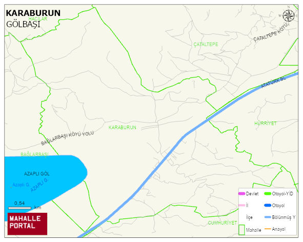
KARABURUN Village Digital Map | All Neighbourhoods and Settlements
KARABURUN Village – Population, Postal Code, Number of Workplaces
KARABURUN village GÖLBASI district of ADIYAMAN province. UAVT (National Address Database Code) Village Code: 795. Postal Code: 2502. KARABURUN 1 streets and avenues, 94 independent business licensed apartments, 416 residential licensed apartments, 271 households. 859 people live in this settlement. 454 male, 405 female. 174 people have never married, 463 people are married, 16 people are divorced and 45 people have passed away. The number of people aged 60 and over is 210. The population rate of 60+ people is % 24 and the ratio of children under the age of 10 to the population is % 10
Leave a Comment