TOP 10: NÜFUS
İstanbul ilinde,
Kartal ilçesinde, mahalleler içinde,
En fazla nüfus barındıran listesinde 3. Karlıktepe 3. sırada kayıtlı ve öne çıkan bir alandır.
Hane yoğunluğu lider listesinde 3. Karlıktepe istatistik listelerinde 3. sırada yer almaktadır.
En fazla konuta sahip listesinde 4. Karlıktepe istatistiksel olarak 4. sıradadır.
En çok işletmenin bulunduğu listesinde 5. Karlıktepe sıralamada beşinci sırada yer almaktadır.
En fazla sokağa sahip listesinde 2. Karlıktepe ikinci sırada yer almaktadır.
| Adi | KARLIKTEPE Province Affiliated | ISTANBUL District Affiliated | KARTAL Postal code | 34870 Number of Streets | 171 Population Density km2-people | 24685.41 Number of Apartments with business Licenses | 1692 Number of Apartments with Residential Licenses | 15486 Number of Households / Families | 11572 Total Population | 33479 Male Population | 16440 Woman Population | 17039 Income Per Person - Spendable TL-Month | 26.829 |
|---|
KARLIKTEPE Neighbourhood Map | Detailed Villages and Neighbourhoods
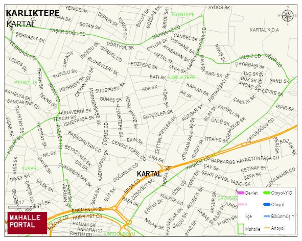
KARLIKTEPE Neighbourhood Digital Map | All Neighbourhoods and Settlements
KARLIKTEPE Neighbourhood – Population, Postal Code, Number of Workplaces
KARLIKTEPE neighborhood is located in KARTAL district of ISTANBUL province. UAVT (National Address Database Code) Neighborhood Code: 40562. Postal Code: 34870. The population density is -per square kilometer- 24715 people. KARLIKTEPE 171 streets and avenues, 1742 independent business licensed apartments, 15154 residential licensed apartments, 11631 households. 33536 people live in this settlement. 16432 male, 17104 female. 8166 people have never married, 16416 people are married, 2075 people are divorced and 1510 people have passed away. The number of people aged 60 and over is 5234. The population rate of 60+ people is % 15 and the ratio of children under the age of 10 to the population is % 10 KARTAL -in the district- 3. the most crowded neighbourhood.