KOYUNBABA Village Digital Map | Updated Neighbourhood Map
Kırklareli ilinde,
Merkez ilçesinde, köyler içinde,
Üniversite mezuniyeti oranında önde listesinde 5. Koyunbaba beşinci sırada konumlanan mahallelerden biridir.
Banka ATM’lerinde lider konumda listesinde 1. Koyunbaba birinci konumda, en üstte bulunan mahalledir.
Merkez ilçesinde, köyler içinde,
Üniversite mezuniyeti oranında önde listesinde 5. Koyunbaba beşinci sırada konumlanan mahallelerden biridir.
Banka ATM’lerinde lider konumda listesinde 1. Koyunbaba birinci konumda, en üstte bulunan mahalledir.
| Adi | KOYUNBABA Province Affiliated | KIRKLARELI District Affiliated | MERKEZ Postal code | 39201 Number of Streets | 1 Population Density km2-people | 9.11 Number of Apartments with business Licenses | 41 Number of Apartments with Residential Licenses | 354 Number of Households / Families | 155 Total Population | 332 Male Population | 182 Woman Population | 150 Income Per Person - Spendable TL-Month | 7.240 |
|---|
KOYUNBABA Village Map | Terrain and Topography
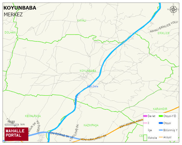
KOYUNBABA Village Digital Map | Updated Neighbourhood Map
KOYUNBABA Village – Population, Postal Code, Number of Workplaces
KOYUNBABA village MERKEZ district of KIRKLARELI province. UAVT (National Address Database Code) Village Code: 19499. Postal Code: 39201. KOYUNBABA 1 streets and avenues, 40 independent business licensed apartments, 353 residential licensed apartments, 158 households. 323 people live in this settlement. 171 male, 152 female. 60 and over is 151. The population rate of 60+ people is % 46
Leave a Comment